Physical Address
23,24,25 & 26, 2nd Floor, Software Technology Park India, Opp: Garware Stadium,MIDC, Chikalthana, Aurangabad, Maharashtra – 431001 India
Physical Address
23,24,25 & 26, 2nd Floor, Software Technology Park India, Opp: Garware Stadium,MIDC, Chikalthana, Aurangabad, Maharashtra – 431001 India
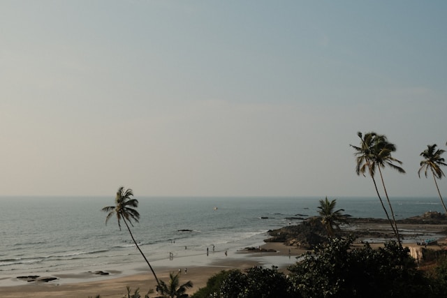
Coastal flooding is no longer a distant threat. It is already reshaping cities, economies, and lives. A recent study published in Science Advances offers a detailed look at how this risk is distributed and why it is intensifying. The paper, A comprehensive flood risk assessment framework for US coastal cities, uses the US Gulf and Atlantic coasts as a test bed to build a data-driven framework that identifies which cities face the greatest danger and what factors drive that risk.
Its conclusions extend far beyond the United States. They hold clear lessons for countries across the Indian subcontinent, where rapid urban growth and climate pressures are colliding along vulnerable coastlines.
The study stands out for its method. It does not rely only on flood maps or rainfall projections. Instead, it uses historical flood damage data, paired with sixteen indicators that capture hazard, exposure, and vulnerability. It then applies three machine learning models, support vector machine, random forest, and multilayer perceptron, to estimate risk under two scenarios. One captures general flood damage, while the other focuses on extreme damage where buildings are destroyed. This distinction matters because it shows that not all floods carry the same consequences, even within the same city.
The findings are clear and difficult to ignore. A relatively small share of land along the US coasts falls into high risk categories, yet a large share of the population lives in those areas. Under the general damage scenario, just over one percent of the land accounts for nearly seventeen percent of the exposed population. Under the extreme scenario, even smaller areas still contain millions of people. This mismatch between land area and population density drives much of the risk.
The study identifies eight cities with especially high exposure. New York City has the largest number of people at risk, with more than 4.7 million exposed under general flood conditions and 4.4 million under extreme scenarios. New Orleans presents a different pattern. Nearly all of its population faces high risk, close to 99 percent in both scenarios. These two cities illustrate how flood risk can take different forms. One concentrates large numbers of people in exposed zones. The other places almost an entire population within reach of floodwaters.
The key factors remain the same across cases. Low elevation remains one of the strongest predictors of flood risk. High drainage density also plays a major role, especially in extreme events. Areas with dense networks of rivers and channels can move water quickly, which raises flood peaks. Population density adds another layer. The more people and infrastructure concentrated in a flood-prone area, the greater the damage when flooding occurs.
Extending the Risk Lens to South Asia
These patterns are not unique to the United States. Across the Indian subcontinent, similar conditions are already visible. Coastal cities combine low elevation, dense populations, and stressed infrastructure. The result is a growing exposure to both frequent and severe flooding.
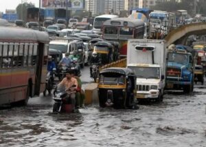
Take Mumbai as an example. The city has faced repeated flooding events, including the 2005 Mumbai floods that caused widespread disruption and loss of life. A detailed analysis of the Mithi River catchment by Indian Institute of Technology Bombay shows how rapid urbanisation and land-use change have increased surface runoff and reduced natural drainage capacity, intensifying flood risk. Much like New York City, Mumbai’s dense built environment limits infiltration and increases runoff. At the same time, sea level rise slows the drainage of stormwater into the Arabian Sea, compounding the city’s vulnerability to both frequent and severe flooding.
A recent study using satellite data shows that large parts of Kolkata face recurring flooding, with over 30 percent of the city affected in recent years due to urban expansion and wetland loss. Research also shows that flooding is concentrated in low-lying, densely populated areas with poor drainage, increasing risks for vulnerable communities.
Bangladesh presents the most extreme case of these intersecting risks. Cities like Dhaka face flooding driven by rivers, intense rainfall, and storm surges from the Bay of Bengal. The Intergovernmental Panel on Climate Change Sixth Assessment Report identifies Bangladesh as one of the most flood-exposed countries globally. The same drivers identified in the US study, hazard, exposure, and vulnerability, converge here with greater intensity and fewer buffers.
Sri Lanka’s coastal regions show similar trends. In Colombo, flooding has become more frequent as rapid urban growth has reduced natural drainage capacity. A World Bank assessment notes that flooding disrupts livelihoods and infrastructure across the city each year. Research also shows that continued wetland loss and unplanned development are increasing future flood risk, even as infrastructure measures are introduced. This mirrors the role of drainage density identified in the US study. When natural and built drainage systems are overwhelmed, flood impacts escalate quickly.
What makes the Science Advances study useful is not just its findings, but its framework. By combining hazard, exposure, and vulnerability, it offers a more complete picture of risk. Many earlier studies have focused mainly on hazard. They map where floods are likely to occur. That approach misses a key point. Flood risk depends just as much on who and what is in harm’s way, and how prepared they are.
This gap is visible in parts of India. Flood forecasting systems have improved, but risk assessments often remain fragmented. India’s flood management strategy has increasingly shifted toward prevention and preparedness, with national guidelines emphasising early warning systems, improved drainage, and integrated planning.
The distinction between general and extreme flood damage also has clear relevance. In many Indian cities, frequent minor flooding is treated as a routine disruption. Roads flood, traffic slows, and daily life is affected. These events rarely lead to major policy changes. Extreme floods, on the other hand, cause large-scale damage and draw attention. By separating these two scenarios, the study shows that different factors may drive each type of risk. This insight can help target interventions more effectively.
Policy responses need to reflect these differences. The US study points to a mix of approaches. Land use regulation can limit development in high-risk zones. Green infrastructure can reduce runoff by increasing infiltration. Wetlands and floodplains can store excess water. Gray infrastructure such as levees and pumps remains necessary, but it works best when combined with natural systems.
These lessons apply directly to the Indian subcontinent. In cities like Mumbai and Kolkata, restoring wetlands and improving drainage systems could reduce both frequent and extreme flooding. In Bangladesh, strengthening embankments and improving early warning systems remain essential. In Sri Lanka, better urban planning could reduce exposure in flood-prone areas.
There is also a social dimension that cannot be ignored. Vulnerability plays a central role in determining outcomes. The US study includes indicators such as poverty, education, and age. These factors influence how well communities can prepare for and recover from floods. In South Asia, where large populations live in informal settlements, vulnerability is often high. A UN-Habitat report on urban risk highlights this disparity.
The global scale of the problem is clear. According to data cited in the study, around 1.81 billion people worldwide are exposed to significant flood risk. A large share of them live in Asia. Economic exposure is also high, with trillions of dollars in assets located in flood-prone areas. As sea levels rise and extreme rainfall events become more common, these numbers are likely to increase.
The framework developed in this research offers a way forward. It provides a method that can be adapted to different regions. It relies on data that is increasingly available, from satellite imagery to census information. It produces results that can guide policy decisions, from infrastructure investment to land use planning.
The message is direct. Flood risk is not just about water levels. It is about where people live, how cities grow, and how societies prepare for change. The patterns identified along the US coasts are already visible across the Indian subcontinent. The difference lies in how quickly and effectively they are addressed.
References
https://www.science.org/doi/10.1126/sciadv.aec2079
https://dspace.library.iitb.ac.in/jspui/handle/100/17472
https://www.sciencedirect.com/science/article/abs/pii/S027311772501525X
https://www.tandfonline.com/doi/full/10.1080/23570008.2021.1957641
https://www.ipcc.ch/report/ar6/wg2/chapter/chapter-10
https://www.worldbank.org/en/results/2018/09/24/metro-colombo-urban-development-project
https://www.sciencedirect.com/science/article/pii/S2212420918314845
https://www.nidm.gov.in/PDF/pubs/NDMA/3.pdf
https://unhabitat.org/world-cities-report-2020-the-value-of-sustainable-urbanization
Banner Image: Wikimedia Commons
Sections of this article may have been developed with the assistance of artificial intelligence tools to support research, drafting and language refinement. All information has been reviewed, edited and verified by the author/editor to ensure accuracy, context and editorial integrity. The responsibility for the final content, interpretations and conclusions rests solely with the publisher.