Physical Address
23,24,25 & 26, 2nd Floor, Software Technology Park India, Opp: Garware Stadium,MIDC, Chikalthana, Aurangabad, Maharashtra – 431001 India
Physical Address
23,24,25 & 26, 2nd Floor, Software Technology Park India, Opp: Garware Stadium,MIDC, Chikalthana, Aurangabad, Maharashtra – 431001 India
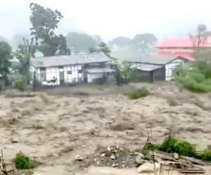
In the eastern Himalayas, a single violent night of rain can now redraw a district’s map. That is close to what residents of Deomali, in Arunachal Pradesh’s Tirap district, have been living through this month, after flash floods tore through roads, bridges and village communication links, leaving the subdivision struggling to reach basic services. By 24 June, the damage had reached the lifeline itself, with landslides slicing through National Highway 315, the road that stitches Tirap to Assam through the Dihing Patkai forest, and officials warning that continued rain could sever the two states from each other altogether.
Events like these are often called cloudbursts in local conversation, and the word carries a precise meaning. The India Meteorological Department defines a cloudburst as rainfall of 10 centimetres or more in an hour over an area of roughly 10 by 10 kilometres. By that standard, not every ruinous downpour qualifies, even though every cloudburst is, by definition, an extreme rainfall event. For Tirap this month the official framing has been flash floods rather than a formally measured cloudburst, a distinction worth holding on to, because the region’s thin network of hourly rain gauges makes the exact label hard to confirm. The 2022 disaster in the same belt, when a cloudburst flooded Deomali and Namsang, is a reminder of how narrow the line between the two can be.
Whatever the label, the physics is consistent. Arunachal Pradesh sits where moisture-laden monsoon air meets the first steep wall of the Himalaya. As that air is forced upward it cools and releases its water in concentrated bursts, a process known as orographic lifting. A 2025 study places Assam and Arunachal among India’s most flash-flood-prone zones, precisely because of this foothill position and the orographic rainfall it generates. The same paper finds that about three quarters of Indian flash floods are triggered when extreme rain lands on ground already saturated, which is exactly the setup of a long monsoon spell broken by one ferocious cloud.
This is where warming enters the story. A hotter atmosphere holds more water vapour, roughly 7 percent more for every degree Celsius of warming, a relationship called Clausius-Clapeyron. More available moisture raises the ceiling on how much rain can fall once conditions tip into a heavy spell. Researchers at the Indian Institute of Tropical Meteorology note that cloudbursts are projected to grow more frequent and intense as the air warms, while cautioning that India lacks the decades of hourly data needed to prove the trend valley by valley. A 2025 analysis adds a mechanism, arguing that the sharpest jumps in short-duration rainfall intensity come from a shift toward convective, thunderstorm-type rain as temperatures climb, which is the very engine that drives a cloudburst.
The broad signal is robust: short-duration extreme rainfall is intensifying across warming regions, and the Himalaya is warming faster than the global average. Attributing one Tirap flood to climate change is a different and stronger claim, and the data density needed to make it cleanly does not yet exist in this part of the Northeast. The defensible statement is that floods like the ones at Deomali are exactly what a warmer climate makes more likely and more severe, not that any single event was caused by it.
Climate is also not the only lever. The destructive force of a cloudburst is magnified by what people have done to the slopes beneath it. Deforestation, road cutting on unstable hillsides and unplanned building in the path of streams all turn heavy rain into catastrophe. Himachal Pradesh offers a sobering preview of the scale: in the 2025 monsoon alone the state logged 46 separate cloudbursts and losses estimated between 4,000 and 4,800 crore rupees, and its death toll climbed past 400 across the season, with the chief minister publicly tying the devastation to climate change, rising temperatures and shrinking forest cover. That NH-315 runs through the ecologically sensitive Dihing Patkai National Park is a reminder that road, forest and flood risk are braided together in this landscape.
The human weight of these floods falls hardest on subsistence and smallholder economies. When the cloudburst struck Tirap in 2022, tea gardens and fish ponds were submerged and low-lying areas went under, wiping out savings that had taken years to build. This month’s flooding has again cut transport links that carry food, medicine and emergency services into remote villages, the kind of disruption that does not register in headline death tolls but reshapes daily life for months. In a state where settlements and farms cluster along river valleys, the same water that nourishes the land arrives, in a bad year, as a weapon.
The Northeast’s exposure is not anecdotal. An Observer Research Foundation assessment found that India’s 13 Himalayan states and union territories, Arunachal among them, experienced extreme weather on 822 of the 1,186 days between January 2022 and March 2025, with 2,863 lives lost. Against that record, a forecast of sustained monsoon rainfall across the region through the coming months reads less like a routine bulletin and more like a standing warning.
For communities in Tirap and across Arunachal, the practical lesson is preparedness rather than prediction. Denser automatic rain gauges and working early-warning systems, slope stabilisation along highways, limits on construction in stream beds and the protection of upstream forests all reduce how much a single cloud is able to cost. None of this stops the rain. It changes what the rain can destroy. As the monsoon settles in for its longest stretch, the question for the eastern Himalaya is no longer whether the hills will open up again, but whether the valleys below them are ready when they do.
References
Minister Wangki Lowang Inspects Flood-Damaged Infrastructure in Deomali
Crucial Assam–Arunachal Link Cut Off as Landslides Hit National Highway 315
https://www.manoramayearbook.in/current-affairs/india/2024/06/24/cloudburst-upsc-explained.html
https://www.nature.com/articles/s44304-025-00121-3
https://www.climate.rocksea.org/cloudbursts
https://www.nature.com/articles/s41561-025-01686-4
Banner Image: Screengrab from X post
Sections of this article may have been developed with the assistance of artificial intelligence tools to support research, drafting and language refinement. All information has been reviewed, edited and verified by the author/editor to ensure accuracy, context and editorial integrity. The responsibility for the final content, interpretations and conclusions rests solely with the publisher.