Physical Address
23,24,25 & 26, 2nd Floor, Software Technology Park India, Opp: Garware Stadium,MIDC, Chikalthana, Aurangabad, Maharashtra – 431001 India
Physical Address
23,24,25 & 26, 2nd Floor, Software Technology Park India, Opp: Garware Stadium,MIDC, Chikalthana, Aurangabad, Maharashtra – 431001 India

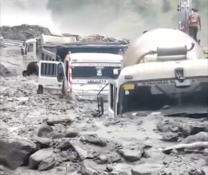
The trucks, bulldozers and tankers parked at one of Jammu and Kashmir’s most ambitious power projects were meant to move mountains. On Monday morning, the mountain moved them instead. Within minutes, a wall of water, mud and boulders swept through the 540 MW Kwar Hydroelectric Power Project site in Kishtwar district, burying heavy machinery under thick layers of debris and stalling construction on a project that is central to the region’s energy plans.
Flash floods triggered by intense overnight rainfall struck multiple parts of the Chenab Valley on July 6, hitting Doda, Kishtwar and Ramban districts. The mud and rock flow at Kwar tore through the Tailrace Tunnel site, damaging project infrastructure, though officials confirmed no casualties. The Doda-Kishtwar stretch of National Highway 244 was blocked near Prem Nagar after floods deposited huge quantities of mud and boulders on the road, stranding vehicles and cutting movement between the two districts. Downstream, authorities opened three gates of the Baglihar Dam as the Chenab rose, and officials advised pilgrims on the ongoing Machail Yatra to avoid the route.
The location matters, and so does the timing. This is the same district where a cloudburst devastated Chishoti village on August 14, 2025, during the Machail Mata Yatra, killing 62 people, leaving 41 missing and presumed dead, and injuring more than 100. Less than a year later, the same valley is again digging vehicles out of debris. The difference this time is luck, not preparedness.
Was it a cloudburst? Why the word matters
Within hours of Monday’s disaster, social media posts and some news reports were already calling it a cloudburst. That claim deserves scrutiny, because the term has a precise meteorological definition that is routinely ignored. The India Meteorological Department classifies an event as a cloudburst only when rainfall exceeds 100 mm in one hour over an area of roughly 20 to 30 square kilometres. To put that in perspective, researchers at the Indian Institute of Tropical Meteorology note that a cloudburst over a 20 square kilometre patch dumps around 2 billion litres of water in a single hour.
Whether Monday’s event meets that bar is not yet known. As Down To Earth reported, IMD data is still awaited, and the flooding may instead be linked to the activity of a low-pressure monsoon trough positioned over the region. This is a recurring problem in Indian disaster coverage: nearly every destructive Himalayan flash flood gets labelled a cloudburst, regardless of whether any rain gauge recorded cloudburst-intensity rainfall. IITM researchers point out that the 2022 Amarnath flash flood was widely attributed to a cloudburst even though no meteorological record in the surrounding region validated the claim. The distinction is not pedantry. Mislabelling every event as a freak, unpredictable cloudburst conveniently shifts attention away from questions about where and how we build in the mountains.
A pattern that runs the length of the Himalaya
Kishtwar is not an outlier. It is the latest data point in a pattern that stretches across every Himalayan state where large hydropower is under construction. In February 2021, an avalanche-triggered deluge in Uttarakhand’s Chamoli district swept through the under-construction 520 MW Tapovan Vishnugad plant, leaving around 150 people dead or missing. A subsequent assessment put the financial impact at around Rs 1,625 crore, with an estimated Rs 3,400 crore needed for debris removal alone.
In October 2023, a glacial lake outburst flood from South Lhonak Lake in Sikkim destroyed the 1,200 MW Teesta III dam at Chungthang. A study published in Science reconstructed the cascade: the flood eroded around 270 million cubic metres of sediment, damaged or destroyed more than 25,900 buildings, washed away 31 major bridges and affected about 270 square kilometres of farmland. At least 55 people were killed and 74 went missing. Ten months later, in August 2024, a major landslide wrecked the powerhouse of the 510 MW Teesta V project downstream, a station that was already shut because of damage from the GLOF. The same month, a dam breach at Malana in Himachal Pradesh triggered floods that killed five people. Neither Teesta III nor Teesta V has generated electricity for almost two years.
Jammu and Kashmir, Himachal Pradesh, Uttarakhand, Sikkim: four states, four corridors, one recurring story. And the next chapter is already being written in the eastern Himalaya, where mega projects are moving forward on the Siang and Dibang rivers in Arunachal Pradesh, in terrain at least as fragile as the valleys that have already failed.
Why project corridors amplify the damage
Extreme rainfall is becoming more frequent and more intense in the Himalaya as the climate warms, but rainfall alone does not explain why hydropower sites and highway corridors keep bearing the brunt. Kishtwar, often described as the “Power House of Jammu and Kashmir”, is simultaneously hosting construction of the Kwar, Pakal Dul, Kiru and Ratle projects, alongside large-scale widening of NH-244 and a web of new rural roads. Residents allege that muck generated during excavation is often dumped near natural drainage channels and riverbanks, despite environmental norms requiring designated dumping sites with retaining structures. When intense rain arrives, that loose material is washed downstream, thickening flash floods into debris flows. Locals also point to hill cutting for roads, poor drainage planning and inadequate slope stabilisation as force multipliers for landslides.
The governance failures run deeper than muck management. In the case of Teesta III, the dam’s design flood considered only rainfall events and excluded any GLOF component, even though the South Lhonak risk was known and had been raised by citizens at public hearings as far back as 2006. Clearance processes that evaluate each dam in isolation, rather than assessing the carrying capacity of an entire river basin, keep approving projects whose combined footprint destabilises slopes and chokes drainage.
The questions Monday should force
No lives were lost at Kwar on Monday. That makes this a cheap warning, and cheap warnings are the only kind worth heeding. Three questions follow. First, will the IMD’s verdict on whether this was a cloudburst or trough-driven rainfall be reported with the same energy as the initial claims? Second, will muck disposal and slope stabilisation practices along the Chenab corridor be audited before, rather than after, the next debris flow? Third, will design floods for the Chenab cascade be recalculated for a climate in which yesterday’s rare event is today’s monsoon?
The Himalaya is not opposed to development. It is indifferent to it. The mountains will keep sending the same message every monsoon, written in mud and boulders across highways and turbine halls. Whether anyone downstream is reading it remains the only open question.
References
Landslide Near Kwar Hydropower Project Buries Vehicles, Closes NH-244 in Kishtwar
What are cloudbursts? Why do they occur and how can cloudburst risks be reduced? [Explainer]
https://www.science.org/doi/10.1126/science.ads2659
Banner Image: Screengrab from PB-SHABD on X
Sections of this article may have been developed with the assistance of artificial intelligence tools to support research, drafting and language refinement. All information has been reviewed, edited and verified by the author/editor to ensure accuracy, context and editorial integrity. The responsibility for the final content, interpretations and conclusions rests solely with the publisher.