Physical Address
23,24,25 & 26, 2nd Floor, Software Technology Park India, Opp: Garware Stadium,MIDC, Chikalthana, Aurangabad, Maharashtra – 431001 India
Physical Address
23,24,25 & 26, 2nd Floor, Software Technology Park India, Opp: Garware Stadium,MIDC, Chikalthana, Aurangabad, Maharashtra – 431001 India
We all know that the location of Sri Lanka is one of geographical, commercial, economic, and aesthetic importance. At the same time, Sri Lanka’s location is prone to various natural disasters. The world’s small island countries are vulnerable to natural disasters and the effects of climate change.
The most frequent natural hazards that impact Sri Lanka are droughts, floods, landslides, cyclones, and coastal erosion. A rise in extreme events and natural disasters due to climate change is expected to threaten Sri Lanka’s economy and human health considerably. Climates, such as flooding, landslides, extreme winds, and drought, cause 96 percent of disasters in Sri Lanka. Sri Lanka ranked the fourth most climate change-affected country in 2016, according to the Global Climate Risk Index, 2018.
Droughts in Sri Lanka
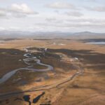
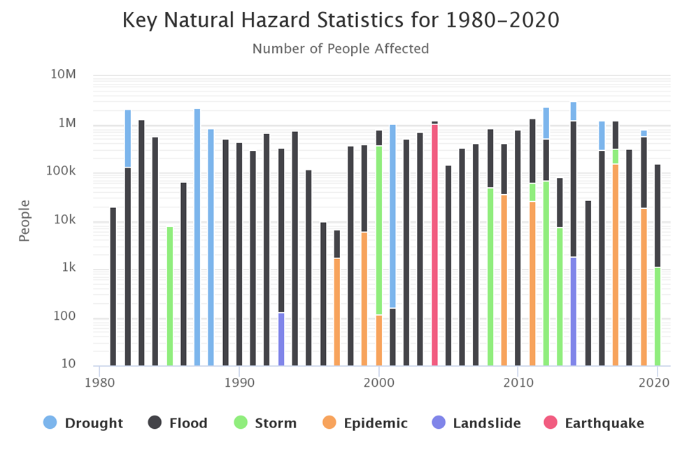
A drought is a period when an area or region experiences below-normal precipitation. The lack of adequate rainfall, rain or snow, can cause reduced soil moisture or groundwater, diminished stream flow, crop damage, and a general water shortage. A small tropical island close to the equator shows the critical impact of warm climate conditions. The seasonal distribution in Sri Lanka shows that droughts occur mainly in August. Most affected appear to be the Kurunegala, Puttalam, Hambantota, Moneragala, and Ampara districts. People were most affected by severe droughts that occurred in the years 2001 and 2004. The damages and economic losses due to the flood and droughts are very high, and it will affect many people each year. Drought is the most critical climatological hazard, and often, human action aggravates it. Most people in rural areas use groundwater for domestic purposes; their livelihood is highly dependent on agriculture. Therefore people in rural areas are highly vulnerable to drought. Thus developing a drought monitoring system for Sri Lanka will help reduce the people’s vulnerability to soaping their day-to-day activities to the drought conditions. But it is a challenging task.
Recently, in 2017 more than 1.2 million people across 19 out of 25 districts remained affected by drought. Northern, North-Central, and Eastern Provinces are reported to have low water levels for agricultural, drinking, and household use. In addition, the failure of two harvests in 2017 has raised concerns for affected communities’ food security and livelihoods. In 2020, commonly there were over 301,000 people in 14 districts in 8 provinces affected by drought, according to the Disaster Management Centre. Drinking water distribution occurred in six areas Sabaragamuwa, Central, Western, North Western, North Central, and Eastern provinces. This drought condition is usually reported in aril to September period of the year.
Climate change has further altered the natural pattern of droughts, making them more frequent, longer, and more severe. While the intricacies of the climate change-drought connection are still being uncovered, scientists agree that Droughts will likely become more intense into the 2050s and beyond.
Floods
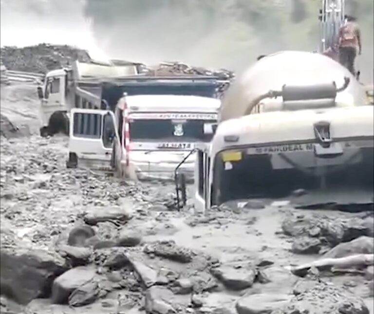
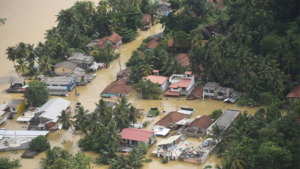
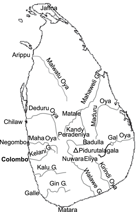
Floods are the most frequent type of natural disaster and occur when an overflow of water submerges, usually dry land. Sri Lanka’s climate shows significant change twice yearly due to the equatorial monsoon. First, it shows the southwest monsoon from May to September and the northeast monsoon from December to February. In this, the northwest monsoon provides more rainfall across Sri Lanka, causing climate change. The southwest monsoon typically peaks from late May to the beginning of June in Sri Lanka, with prevailing winds from the south and southwest streaming toward the Bay of Bengal. The areas that usually receive the heaviest rain are the south and west of the country, including Kalutara, Ratnapura, and Colombo. So, the southwest monsoon period is the response to flood events occurring in the western, sabragamuwa, and southern provinces of Sri Lanka—the northeast monsoon response to flood disasters occurring in the eastern and northern parts of Sri Lanka heavily.
Concerning spatial distribution, floods are most frequent in Jaffna, Kalutara, Rathnapura, Gampaha, and Ampara districts. People have become increasingly affected by floods, with the highest number recorded in 2008. occurrence of deaths due to floods is relatively low except for 2003 when it reached nearly 180 persons. Destruction and damage to houses and buildings also appear to follow a similar pattern, with most damage occurring in the districts of Rathnapura, Ampara, Batticaloa, Polonnaruwa, and Jaffna. Damage to paddy mainly happened earlier, with the highest impact recorded in 1984.
As far as Sri Lanka is concerned, the country has many rivers all over the country. Due to this, the rivers overflow and cause floods in case of heavy rainfall. Therefore, areas near those rivers quickly become flood-prone areas.
Many factors can go into the making of a flood. First, there are weather events (heavy or prolonged rains, storm surges, sudden snowmelt). Then there are the human-driven elements, including how we manage our waterways (via dams, levees, and reservoirs) and the alterations we make to land. Increased urbanization, for example, adds pavement and other impermeable surfaces, alters natural drainage systems, and often leads to more homes being built on floodplains. In cities, under-maintained infrastructure can lead to urban flooding. More and more, flooding factors are also linked to climate change.
As climate change warms the atmosphere, the air can hold 7% more water vapor for every one-degree Celsius rise. When this air rapidly cools, water vapor turns into droplets, joining together to form heavy rainfall. According to the recently released IPCC’s sixth assessment report, climate impacts are at the high end of previous estimates, affecting all parts of the world. This report also mentions that about 40% of the world population (approximately 3.5 billion people) may be affected by the most severe category of “high vulnerability” related climatic impacts.
The land has warmed by more than 0.5 C compared with the global mean temperature after 1990. Increasing earth temperatures are attributable to greenhouse gas emissions and resultant responses in the earth system. It was evident that this warming has affected changes in weather and extreme events globally.
Land Slides
A landslide is the movement of a mass of rock, debris, or earth down a slope. Landslides are a type of “mass wasting,” which denotes any down-slope action of soil and rock under the direct influence of gravity. Landslides are a serious geologic hazard common to almost every hill district in Sri Lanka. Of the 65,000 sq km of the land extent of Sri Lanka, an area of nearly 20,000 sq km encompassing ten districts is prone to landslides. It is about 30% of Sri Lanka’s land area and is spread into several districts: Badulla, Nuwara Eliya, Kegalle, Ratnapura, Kandy, Matale, Kaluthara, Mathara, Galle, and Hambantota. The background for a
landslide to move down a slope is created by various environmental factors. Undue human activities persisting for long periods are finally triggered by intensive rainfall to a landslide. The heavy rain not only causes water penetration into the subsoil layers, thereby losing the interlayer cohesion, but also increases the weight of soil mass. Floods and reservoirs in hill areas can influence the incidence of landslides in several ways. One such instance is
the failure of riverbanks scoured by following swollen rivers after heavy rains. The bottom areas of the banks are eroded by the flowing river water leaving the top regions in the riverbanks without the toe support, which can easily cause the maximum mass to come down.
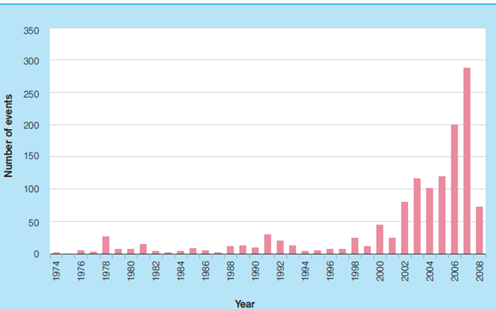
In Sri Lanka, until 2002, the annual average number of landslide records was at most 50. However, the data shows a sudden increase in landslides from 2003 – 2008. The descriptions of landslides are high in May and June and once again from November to January, showing a clear relationship between the two monsoon seasons in Sri Lanka. The second peak is higher than the first, and November has the highest recorded landslides, exceeding more than 275 incidents. The highest impact can be seen in Badulla, NuwaraEliya, Kandy, and Rathnapura districts. A similar pattern can be seen on the map for DS divisions, where the highest impact can be observed in DS divisions in the Uva Province.
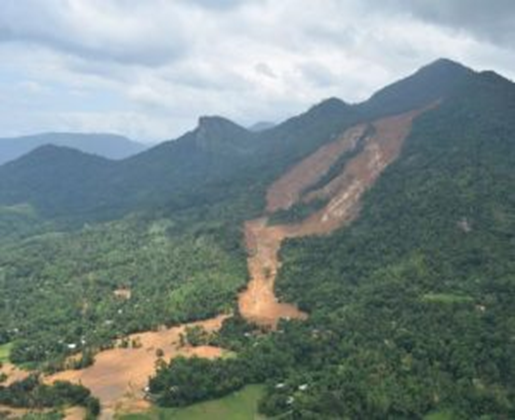
A landslide of large magnitude occurred in Aranayaka Divisional Secretariat on 17-05-2016. Two more were followed the next day early morning. This completely buried parts of several villages killed over 150 people, and destroyed many houses. The primary triggering factor of this landslide was relentless rain for four days, from the 14th to the 17th of May 2016.
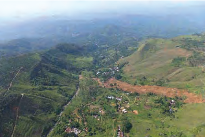
A significant landslide struck Meeriyabedda, located in the Badulla district, on the 29th of October, 2014. The landslide, triggered by continuous rainfall for three consecutive days, affected the workers of the Koslande estate, causing immense damage to their lives and property. As a result, 16 deaths were confirmed, 192 people were believed to be missing, and about 150 homes were buried.
Also, there are several major landslide incidents reported in Sri Lanka. As mentioned above, landslides are also caused by high rainfall, and climate change will likely add strength to this. Cases of human activities can be a contributing factor in causing landslides. Many human-caused landslides can be avoided or mitigated. They are commonly a result of building roads and structures without adequate grading of slopes, poorly planned alteration of drainage patterns and disturbing old landslides.
Cyclone
A cyclone is a general term for a weather system in which winds rotate inwardly to an area of low atmospheric pressure. Types of storms include tropical storms, extratropical cyclones, and tornadoes. Sri Lanka is an island nation in the Indian Ocean. The country is vulnerable to hurricanes due to its position near the confluence of the Arabian Sea, the Bay of Bengal and the Indian Ocean.
In Sri Lanka, The occurrence of wind events over time has been relatively consistent and low. However, a sudden increase can be seen in the latter part of the period, with the highest number of events in 2007.
Wind events are high during April-June and again during November- December. Wind events are most prevalent in Rathnapura, Badulla Anuradhapura, and Colombo districts. Districts such as Mannar, Kilinochchi, Vavuniya, and Mullativu show a lower incidence of wind events due to limited data availability. The majority of them have a low incidence of wind events, with very few numbers experiencing a high incidence. For some divisions in the districts of Mannar, Kilinochchi, Vavuniya, and Mullativu, the low incidence can be attributed to the limited availability of desegregated data at the DS division level.
Global average tropical cyclone wind speed and rainfall will likely increase, and the global average frequency of tropical cyclones will likely decrease or remain unchanged. The frequency of the most intense tropical cyclones may increase substantially in some ocean regions. Therefore, the present hazard level in areas currently affected by tropical cyclones may increase in the long term. Projects in such areas should be robust to future increases in cyclone hazard. People in Sri Lanka have not been very much affected by wind events. However, an exception to this is the years 1978 and 2000. Further, people located in the districts of Anuradhapura, Polonnaruwa, Trincomalee, and Batticaloa have been most affected by wind events.
Cyclones are subject to several climate change-related influences:
Coastal erosion
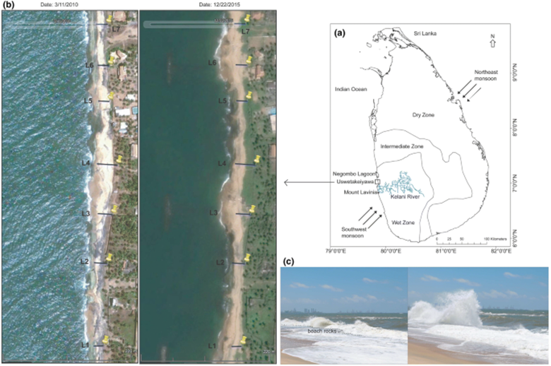
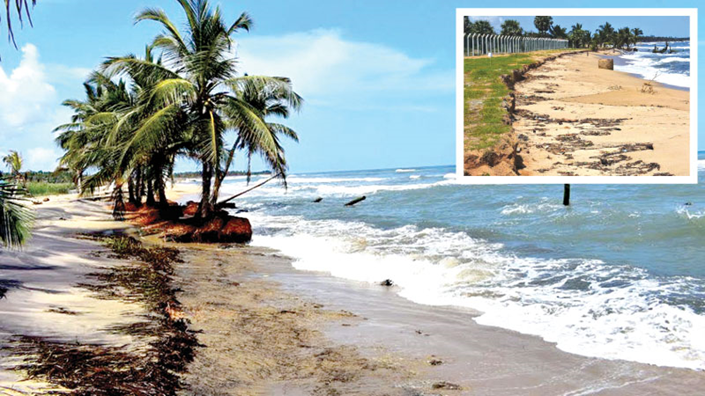
Sri Lanka is an island with a coastline approximately 1600 km long and a boundary between the land and the sea to protect the country’s land mass. However, coastal erosion and environmental degradation are accelerating along many country coastal areas due to natural and anthropogenic activities. Most notably, ill-designed coastal structures, the construction of hotels and other buildings too near the shoreline, and sand and coral mining. Coastal erosion is a natural and significant problem for developed shorelines everywhere today. The landward displacement of the shoreline caused by the forces of waves and currents is termed Coastal Erosion. As a result, the Coastal areas have become more prone and vulnerable to natural and human-made hazards, which lead to Coastal Erosion.
The country’s coastal environment is beautiful and consists of rich biodiversity and different kinds of natural resources. Hence, the land area on the coastal belt has high environmental value and high economic and social demands. In addition, the coastal area is densely populated, with more than 65 percent of the total country’s population, and is a developed area in the country and contains the capital city of Colombo and several large cities. The total population in the coastal belt is projected to be 8.4 million in 2010.
More storms and higher seas from climate change create more winds, waves, and floods, leading to coastal erosion. Hurricanes can wash away sandy barrier islands, leaving coastlines and islands unprotected from future storm surges. Climate change threatens coastal areas already stressed by human activity, pollution, invasive species, and storms. Sea level rise could erode and inundate coastal ecosystems and eliminate wetlands. Warmer and more acidic oceans are likely to disrupt coastal and marine ecosystems.
Global warming causes sea-level rise as oceans to expand, making storm patterns more energetic. Consequently, inundation and increased erosion will affect most of the world’s coastlines. Therefore, sound predictions of the development of these hazards over the next century are needed to manage the resulting risks. Coastal flooding is somewhat easier to predict than erosion since inundation can be estimated using coastal contours. However, its prediction is not trivial since inundation may be followed by rapid reshaping of the shoreline by, amongst other things, waves, tidal currents, and human interventions.
-With inputs from Dinesh Balasri –