Physical Address
23,24,25 & 26, 2nd Floor, Software Technology Park India, Opp: Garware Stadium,MIDC, Chikalthana, Aurangabad, Maharashtra – 431001 India
Physical Address
23,24,25 & 26, 2nd Floor, Software Technology Park India, Opp: Garware Stadium,MIDC, Chikalthana, Aurangabad, Maharashtra – 431001 India
By K.R.Abhayasingha
Visiting lecturer, Post Graduate Institute of Science (PGIS), University of Peradeniya (Retired Director of Meteorology)
The world has been made aware by the WMO (World Meteorological Organization) and some climate agencies that this year, 2023, was going to be an El Nino year. Before discussing the real meaning of that warning, let us briefly discuss the movement of air around our earth.
The earth is surrounded by the atmosphere, which consists of a mixture of a number of gases, water vapor (moisture), dust, and minute particles. Our atmosphere fills the area between the surface of the earth and an altitude of about 100km. Even though we cannot visualize the movement of air above us, atmospheric air masses move from place to place, and it is described as air circulation or wind.
As a result of the long-time studies done by a number of scientists, a three-cell model describing the air movement within the atmosphere was proposed and accepted. Accordingly, atmospheric movements take part in three parts which are 1) the area margined by the equator and latitude of 30 degrees, 2) the area margined by latitudes 30 and 60 degrees, and 3) the area margined by latitudes 60 and 90 degrees. Hence, three cellular movements of air are within each hemisphere (Fig 1)..

Figure 1-Three cell model of atmospheric circulations
After the lengthy observations by climate scientists Hadley and Walker, Hadley concluded that there are large-scale air movements in cells in the North-south direction, and they were named Hadley cells (Fig 2). Walker concluded that there are large-scale air movements in cells in the East-West direction, which were named Walker cells (Fig 3).

Figure 2. Hadley Cells
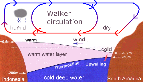
Figure 3= A Walker cell
As the air moves from place to place, it transports atmospheric characteristics like warmness(Temperature) and moisture concentration (humidity), and the weather and the climate in a location or in an area are developed by these characteristics. Therefore, weather and climate forecasting are based on analyses of air movement around the earth. Similarly, the climate seasons of any area are based on wind directions and speeds persisting over that area.
After analyses of such data over the Sri Lanka area, the climate over our area has been decided to consist of four seasons. The climate experienced during a 12-month period (one year) in Sri Lanka can be categorized into four (4) seasons, climate seasons, as follow. Each season has its typical features.
i. First Inter-monsoon season (FIM) March – April
ii. Southwest Monsoon season (SWM) May – September
iii. Second Inter-monsoon season (SIM) October- November
iv. Northeast Monsoon season (NEM) December – February
The above categorization is based on the distribution of the weather parameters, mainly pressure and wind, over the Sri Lanka area. Since the island’s topography is so extensive, lowland areas surround the central hills; in addition to weather parameters, ground characteristics also cause the variation of climate during each season.
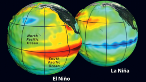
When the global weather characteristics are considered, on average, the Pacific Ocean is characterized by warm temperatures and low pressure over the western part and cold temperatures and high pressure over the eastern part. Accordingly, the Walker cell over the Pacific Ocean area is composed of east-to-west wind over the sea surface and west-to-east wind at high altitudes. Also, upward winds over the western part and downward winds over the eastern part of the Pacific Ocean can be observed. (upper diagram of Figure 4.)
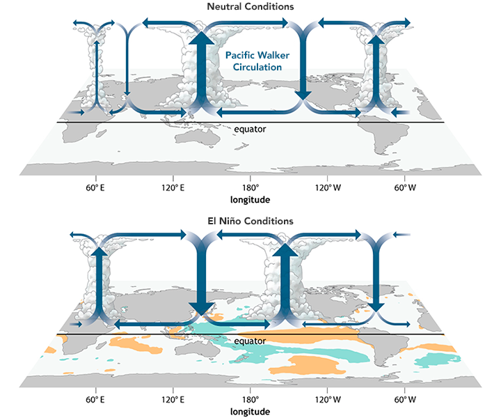
Figure 4. Walker cell over the Pacific area (average in the upper figure and El Nino situation in the lower figure)
Now let us discuss the El Nino effect.
Due to a number of natural reasons, surface waters of the Eastern Pacific become warm, and hot El Niño is the warm phase of a recurring climate pattern across the tropical Pacific. The pattern shifts back and forth irregularly every two to seven years, bringing predictable shifts in ocean surface temperature and disrupting the wind and rainfall patterns across the tropics. These changes have a cascade of global side effects.
The warmness of seawater changes in the north-South direction around the equator due to natural reasons; hence, this oscillation is known as El Niño Southern Oscillation (ENSO).
El Niño (and ENSO) significantly influence climate patterns in various parts of the world. This naturally occurring phenomenon involves fluctuating ocean temperatures in the central and eastern equatorial Pacific, coupled with changes in the atmosphere. Scientific progress in understanding and modeling this phenomenon has improved prediction skills to within a range of one to nine months in advance, allowing society to prepare for associated hazards such as heavy rains, floods, and drought.
As the direction of wind streams and wind speeds of Walker cells over the Pacific Ocean tend to change in El Nino situations, it will cause changes in other walker cells around the world. As indirect effects, significant changes of Hadley cells over the world are also caused, which will ultimately cause significant changes and fluctuations of weather conditions over many parts of the world, including Asia. As our planet is interconnected, patterns and events in one place can affect life half a world away.
Episodic shifts in winds and water currents across the equatorial Pacific can, In El Nino conditions, cause floods in the South American desert while stalling and drying up the monsoon in Indonesia, India, and Sri Lanka area. Atmospheric circulation patterns that promote hurricanes and typhoons in the Pacific can also knock them down.
During an El Niño event, the surface waters in the central and eastern Pacific oceans become significantly warmer than usual. That change is intimately tied to the atmosphere and to the winds blowing over the vast Pacific. Easterly trade winds (which blow from the Americas toward Asia) falter and can even turn around into westerlies. This allows great masses of warm water to slosh from the western Pacific toward the Americas. It also reduces the upwelling of cooler, nutrient-rich waters from the deep—shutting down or reversing ocean currents along the equator and along the west coast of South and Central America.
The circulation of the air above the tropical Pacific Ocean responds to this tremendous redistribution of ocean heat. The typically strong high-pressure systems of the eastern Pacific weaken, thus changing the balance of atmospheric pressure across the eastern, central, and western Pacific. While easterly winds tend to be dry and steady, Pacific westerlies tend to come in bursts of warmer, moister air.
Because of the vastness of the Pacific basin—covering one-third of the planet—these wind and humidity changes get transmitted around the world, disrupting circulation patterns such as jet streams (strong upper-level winds). We know these large-scale shifts in Pacific winds and waters initiate El Niño. What we don’t know is what triggers the shift. This remains a scientific mystery.
As El Nino causes changes in the strength and direction of Hadley cells also, the weather conditions in the Southwest monsoon season in Sri Lanka are normally affected. Normally El Nino effects lead to weak monsoon conditions over the country.
What is not a mystery is that El Niño is one of the most important weather-producing phenomena on Earth, a “master weather-maker,” as author Madeleine Nash once called it. The changing ocean conditions disrupt weather patterns and marine fisheries along the west coasts of the Americas. Dry regions of Peru, Chile, Mexico, and the southwestern United States are often deluged with rain and snow, and barren deserts have been known to explode in flowers. Meanwhile, wetter regions of the Brazilian Amazon and the northeastern United States often plunge into months-long droughts.
El Niño events occur roughly every two to seven years. The warm cycle alternates irregularly with its sibling La Niña—a cooling pattern in the eastern Pacific—and with neutral conditions. El Niño typically peaks between November and January, though the buildup can be spotted months in advance, and its effects can take months to propagate around the world.
Though El Niño is not caused by climate change, it often produces some of the hottest years on record because of the vast amount of heat that rises from Pacific waters into the overlying atmosphere. Major El Niño events—such as 1972-73, 1982-83, 1997-98, and 2015-16—have provoked some of the great floods, droughts, forest fires, and coral bleaching events of the past half-century.
El Nino effect and the current climatic situation in Sri Lanka
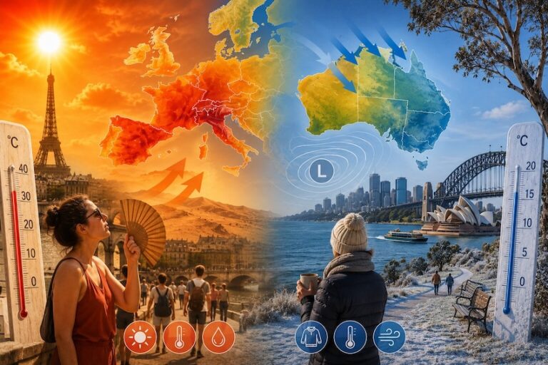
Sri Lanka, as a tropical country, can see sudden changes in climate these days. Through the analyses of the observed temperature values over the Pacific Ocean, which contains about 80 percent of the ocean’s volume, it has been concluded that the average temperature of the ocean waters of the Pacific is 38.3 °F (3.5 °C). Due to transporting of warm waters by the ocean water currents towards the Pacific, the temperature of the seawater rises, causing the development of El Nino systems, which has been observed to occur periodically. During an El Niño, water temperatures in the Pacific Ocean may rise on average 3 – 5 degrees above average.
As the specific climate conditions persisting during the first Inter Monsoon season, atmosphere around us is warm during this season. As the Sun rises overhead to the land mass of Sri Lanka during 5th to the 15th of April, and the wind close to Earth is light, the lower atmosphere close to the earth surface becomes highly moist and warm. As a result, we experience a very warm atmospheric state throughout the day and night. Depart of Meteorology computes the Heat Index of all parts of Sri Lanka on a daily basis, and according to the information published by that department, the Heat Index, which is the temperature that we feel, is usually above the surface temperature in most of the days in April.
In El Nino situations, as the wind streams in Walker cells become a little warmer than normal, the warmness of the lower atmosphere over Sri Lanka may be enhanced, resulting in higher Heat Indices over the Sri Lanka area. This may be one of the reasons leading us to feel very warm surrounding in April.