Physical Address
23,24,25 & 26, 2nd Floor, Software Technology Park India, Opp: Garware Stadium,MIDC, Chikalthana, Aurangabad, Maharashtra – 431001 India
Physical Address
23,24,25 & 26, 2nd Floor, Software Technology Park India, Opp: Garware Stadium,MIDC, Chikalthana, Aurangabad, Maharashtra – 431001 India

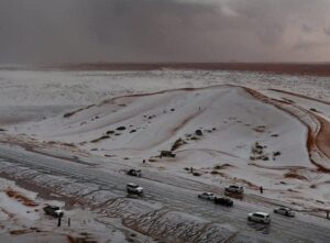
Claim: Viral social media posts claim that Saudi Arabia’s Al-Jawf desert was recently transformed into a snowy landscape, with photos and videos showing sand dunes covered in what appears to be snow. The posts suggest that this unusual phenomenon was caused by a rare mix of moist air from the Arabian Sea and intense desert heat.
“Many people may not know the fact that many Gulf countries have previously experienced snowfall in the winter, and some of the snowfall was heavy and accumulated in a striking manner, similar to what happens in the Levant. Snowfall in the Gulf countries is concentrated on the high mountainous elevations, when the region is affected by air depressions accompanied by very cold air masses.” ArabiaWeather. Read here
Social Media posts
The viral posts have generated widespread fascination and disbelief, as Saudi Arabia is known for its scorching deserts and extreme heat. Many social media users were quick to share the posts, marveling at what they believed to be snow in one of the hottest regions on Earth.
What Really Happened in Al-Jawf?
The Al-Jawf region, located in northern Saudi Arabia, is no stranger to unusual weather events during the winter months. However, snow is an extremely rare occurrence in the area due to its typically dry desert climate. According to meteorological reports, what appeared to be a snowy landscape was actually the result of a severe hailstorm.
Understanding Frozen Precipitation
The difference between hail, snow, sleet, and graupel lies in their formation:
Forms of frozen precipitation. L-R: hail, graupel, sleet, snow. Source: NOAA NSSL
How does hail compare to other types of frozen precipitation?
The primary difference between frozen precipitation is how the different types grow and the maximum sizes of the individual particles.
Snow forms mainly when water vapor turns to ice without going through the liquid stage. This process is called deposition. Snow can form in the gentle updrafts of stratus clouds or at high altitudes in very cold regions of a thunderstorm. Snowflakes that most of us are used to seeing are not individual snow crystals, but are actually aggregates, or collections, of snow crystals that stick or otherwise attach to each other. Aggregates can grow to very large sizes compared to individual snow crystals.
Graupel are soft, small pellets formed when supercooled water droplets (at a temperature below 32°F) freeze onto a snow crystal, a process called riming. If the riming is particularly intense, the rimed snow crystal can grow to an appreciable size, but remain less than 0.2 inches. Graupel is also called snow pellets or soft hail, as the graupel particles are particularly fragile and generally disintegrate when handled.
Sleet are small ice particles that form from the freezing of liquid water drops, such as raindrops. At ground level, sleet is only common during winter storms when snow melts as it falls and the resulting water refreezes into sleet prior to hitting the ground. In thunderstorms, sleet is possible above the melting level where cloud droplets become supercooled and may instantaneously freeze when making contact with other cloud particles or debris, such as dust particles. Sleet is also called ice pellets.
Hail is frozen precipitation that can grow to very large sizes through the collection of water that freezes onto the hailstone’s surface. Hailstones begin as embryos, which include graupel or sleet, and then grow in size. Hailstones can have a variety of shapes and include lumps and bumps that may even take the shape of small spikes. Hailstones must be at least 0.2 inches in size.
Thus, the hailstorm left a significant amount of ice on the ground, which, combined with the desert’s sandy surface, created the illusion of snow. This optical effect was likely amplified in videos and photos, leading to the widespread misinterpretation on social media.
Analysis of Extreme Weather in the Arabian Peninsula
While snow in Saudi Arabia’s mountainous regions, like Tabuk, is not unheard of, snowfall in low-lying desert areas such as Al-Jawf is nearly impossible given the average temperatures. However, the Arabian Peninsula has been experiencing more frequent extreme weather events in recent years, including rare hailstorms, heavy rains, and sudden floods. Read here
Climate scientists suggest that these unusual weather patterns could be linked to broader climate change effects, which have been causing shifts in regional weather patterns and increasing the frequency of extreme events. Read here and here
Conclusion
The viral claims that Saudi Arabia’s Al-Jawf desert turned into a snowy wonderland are misleading. While the region did experience an unusual weather event, it was a hailstorm rather than snowfall that covered the desert. The striking resemblance of hail to snow created the widespread misconception.
References:
https://www.nssl.noaa.gov/education/svrwx101/hail/types
https://www.nature.com/articles/s43017-020-00133-9
https://nsidc.org/learn/parts-cryosphere/snow/science-snow
https://www.arabiaweather.com/en/content/snow-is-expected-in-most-gulf-countries-in-winter-details
https://www.noaa.gov/jetstream/atmosphere/precipitation
https://climateknowledgeportal.worldbank.org/country/saudi-arabia/extremes
https://climate.nasa.gov/extreme-weather.amp
Banner Image: Facebook post
Comments are closed.
I was looking through some of your content on this website and I believe this web site is very informative ! Keep on putting up.
수원출장샵
I like this weblog its a master peace ! .