Physical Address
23,24,25 & 26, 2nd Floor, Software Technology Park India, Opp: Garware Stadium,MIDC, Chikalthana, Aurangabad, Maharashtra – 431001 India
Physical Address
23,24,25 & 26, 2nd Floor, Software Technology Park India, Opp: Garware Stadium,MIDC, Chikalthana, Aurangabad, Maharashtra – 431001 India

What is the claim?
An Instagram post with about 8,000 likes claims that a recent drop in the temperature of the Atlantic Ocean shows that climate change is a ‘lie’. The post includes a screenshot of a headline, “The Atlantic is cooling at record speed and nobody knows why,” of a report published in The New Scientist, a popular science magazine. Multiple similar posts were seen across various other social media platforms.
What is the fact?
The post is misinterpreting the report published in The New Scientist, which is based on NOAA findings and clearly is not claiming that the whole of the Atlantic is cooling. The report also is not negating climate change or the fact that an overall long-term warming trend is being witnessed in Earth’s atmosphere.
What did we find?
We traced the original The New Scientist report published on August 19, 2024, a screenshot of which has been used in the viral posts to deny climate change. We found that not only the report is only talking about parts of the Atlantic ocean as showing an unusual cooling but also has not negated climate change anywhere. We also found that the article is based on some recent NOAA findings.
NOAA found that after experiencing over a year of record-high global sea temperatures, parts of the Atlantic Ocean are now cooling off at an unprecedented rate, a development that could significantly impact global weather patterns. Over the past three months, temperatures in the equatorial Atlantic have shifted from unusually warm to noticeably cooler at a record-breaking pace. This rapid transition marks the emergence of “Atlantic Niña,” a pattern characterized by cooler-than-average sea surface temperatures in the equatorial Atlantic Ocean.
The Reason
This shift is particularly notable because it comes just before the anticipated onset of La Niña in the Pacific Ocean, a climate pattern known for cooling sea surface temperatures in the central and eastern Pacific. La Niña typically follows El Niño and can last for months or even years, bringing ocean conditions that impact weather patterns around the globe. The back-to-back occurrence of the Atlantic Niña and La Niña in the Pacific is highly unusual and could produce significant ripple effects on the world’s weather systems.
The combination of these two cooling patterns in the Atlantic and Pacific is expected to alter atmospheric circulation, potentially influencing weather phenomena such as tropical cyclone activity, rainfall patterns, and temperature fluctuations across different regions. For instance, La Niña is known to intensify hurricane activity in the Atlantic while often reducing it in the Pacific. Meanwhile, the Atlantic Niña could contribute to changes in wind patterns, which may impact the strength and direction of tropical storms and seasonal rainfall distribution, particularly in regions like West Africa and South America.
These emerging patterns may also lead to shifts in global weather extremes. For example, regions that typically experience drier conditions during La Niña, such as the southern United States and parts of South America, may face heightened drought risks. Conversely, areas like Southeast Asia and Australia, which often see increased rainfall during La Niña, could be subject to more intense flooding.
Given the rapid cooling in the Atlantic and the looming La Niña event in the Pacific, scientists and meteorologists are closely monitoring these developments for their potential to impact global weather systems in the months to come significantly.
What is Atlantic Niña?
Atlantic Niña is the cold phase of a natural climate pattern known as the Atlantic zonal mode. “Zonal” refers to patterns that occur along lines of latitude. Like the El Niño-Southern Oscillation (ENSO) in the Pacific, the Atlantic zonal mode alternates between cold and warm phases every few years.
In this pattern, sea surface temperatures in the eastern equatorial Atlantic follow a distinctive seasonal cycle. Interestingly, the warmest waters are observed in spring, while the coldest waters, typically below 25 degrees Celsius (77 degrees Fahrenheit), occur between July and August. This fluctuation between warm and cold phases influences regional weather and climate patterns surrounding the Atlantic Ocean.
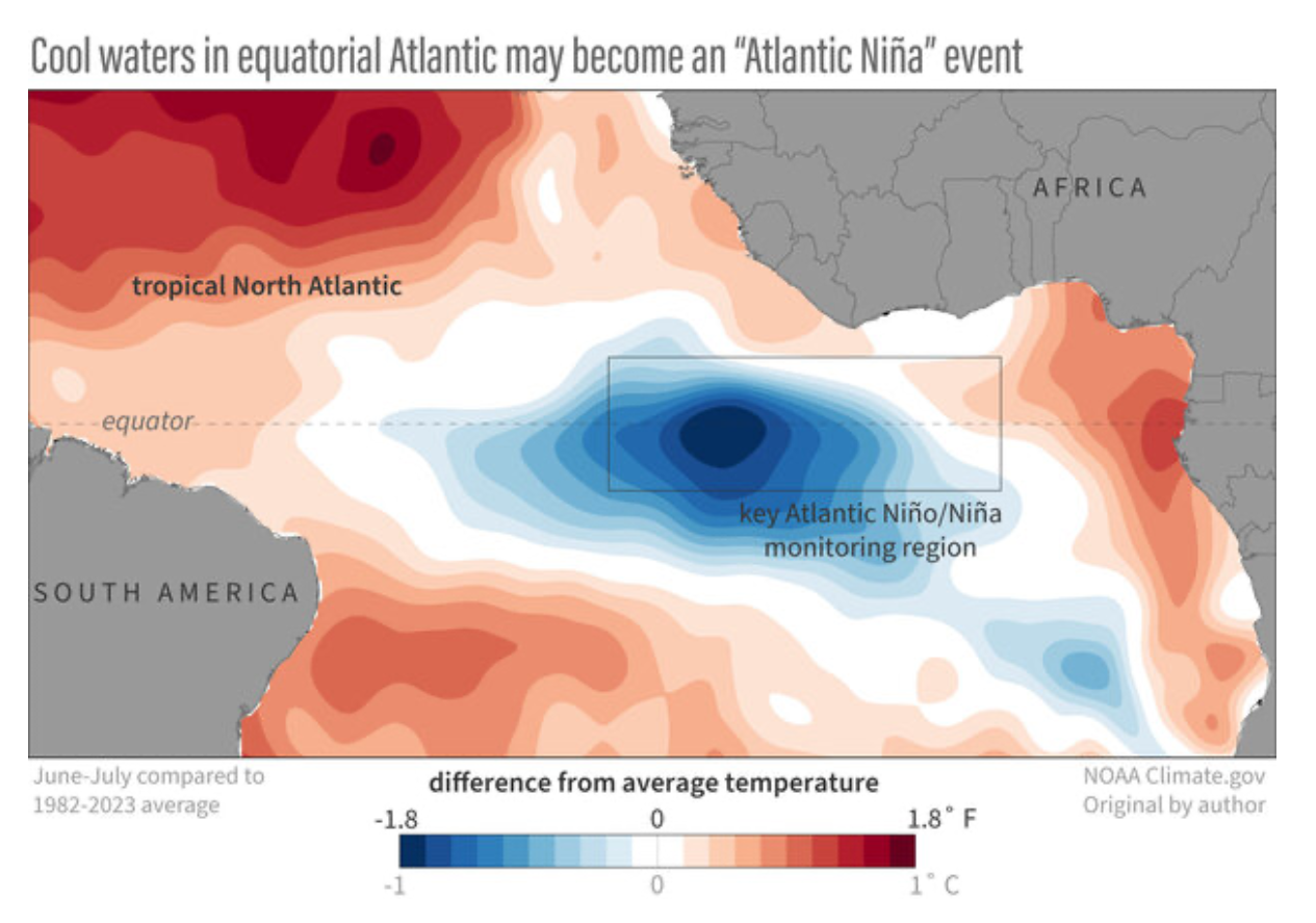
Source: climate.gov
Record surface and ocean temperatures
Michael McPhaden, an oceanographer at NOAA told AFP, “Cooling in the equatorial Atlantic does not contradict the fact that July 2024 was the hottest month ever recorded on Earth due to the relentless rise of greenhouse gas concentrations in the atmosphere.”
Findings by Climate Copernicus’s research also show that average sea surface temperatures were record high in 2024, 21.07C (69.93F), excluding the poles, for 2024.
In 2023 and 2024, global sea surface temperatures reached record highs, as reported by NOAA data analyzed by the University of Maine.
With inputs from Aayushi Sharma
References:
https://www.instagram.com/atlassociety/p/C_J_67At2fa
https://climate.copernicus.eu/surface-air-temperature-july-2024